


Droning out waste
As drone use (ahem) takes off, it’s only a matter of time before they find their place in waste management. In fact, they can already be seen flying over landfills and cropland, monitoring waste, with more applications sure to follow. Libby Peake reports

It seems as though hardly a day goes by lately when you don’t hear about a new application for aerial drones in the environmental sector, whether it be monitoring the health and numbers of grey whales off the coast of California, modelling how sandy rivers respond to human interference and environmental change in Western Canada, or assessing damage from environmental disasters, like the recent earthquakes in Nepal. Given their increasing ubiquity, it’s only a matter of time before drones establish a presence in waste and resource management – indeed, the process has already begun.
And it’s not just the environment where they’re proving popular: according to the Civil Aviation Authority, the body tasked with regulating drone use in the UK, the number of commercial drone users registered in the country has been rapidly increasing in recent years, from 43 in 2010, to 170 in 2013, and 597 as of May 2015. Many drone companies offer services in a variety of sectors – from mining and quarrying to agriculture and environmental inspection – and some of those are already active in waste management.
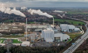
By far the most likely application of drones (or unmanned aerial vehicles (UAVs) to give them their more technical name, though they can equally be referred to as something along the lines of ‘flying robots’) is landfill surveying. According to the Landfill Directive, operators must monitor the topographical structure and composition of the landfill body at least once a year during a landfill’s active life (and continue to monitor the settling behaviour on a yearly basis in the after-care phase), and many operators carry out these useful surveys even more frequently.
Andrew Blogg, Co-founder and Head of Mapping and Surveying at drone company Future Aerial Innovations, claims that using drones could save time and money, as well as resulting in more accurate information, compared to traditional surveying methods. “The results are very similar, in that you wind up with information on the height of the landfill, but it does mean that you don’t have to set foot onto the landfill site itself”, he explains. “And the other main benefit from it is that we can pick up a lot more information… We can pick up millions of points on the landfill to give a much more accurate height calculation and volume calculation as well.”

Using a fixed-wing drone (which looks like an aeroplane), which is more aerodynamic than a multi-rotor model (which more closely resembles a helicopter), Blogg says a landfill site of around one square kilometre could be surveyed in about half an hour, with the drone’s autopilot triggering photos from an attached digital camera every few seconds. Back in the office, these images can then be stitched together using photogrammetry software to create 3D models.
All this can be done with just a normal digital camera, though these are far from the only things that can be attached to drones – other options that have been used in different fields include near-infrared (NIR) or multi-spectral cameras, ground-penetrating radar and heat sensors. The technology is developing rapidly, and in time there will doubtless be many other applications these flying robots can be put to. Below are some of the potential areas in waste and recycling that drones might contribute to in future, some perhaps more feasible than others:
Measuring methane emissions from landfills
A large contingent of researchers from the universities of Manchester, Cambridge, Southampton, Royal Holloway, Bristol, Edinburgh, Leicester and the Technical University of Denmark, as well as practitioners from Ground Gas Solutions and the Environment Agency, recently descended upon a Viridor landfill site in an attempt to measure the biogenic methane it was emitting to the atmosphere (fugitive emissions), using UAVs.
This is a potentially significant development in greenhouse gas emission measurement, as current figures are arrived at by scaling up informed estimates about how much certain sources emit, rather than through measurements quantifying the actual flux of gases being emitted to the atmosphere.
Following a feasiblity study that concluded that small, fixed-wing drones carrying spectroscopic and wind measurement devices ‘would provide precision continuous measurements that would enable flux calculation across the scale of typical landfill sites with an uncertainty broadly estimated to be within 20 per cent’, the Environment Agency has conducted an eight-month project to develop a method for quantifying whole-site-methane emissions from landfills using drones. A report on the project is expected in September.
Hazardous waste removal
Scientists at Imperial College London have developed the world’s first ‘flying 3D printer’, which they hope could eventually be used to perform tasks such as patching up damaged buildings, bridges or dams, or safely removing nuclear waste.
Recent research using aerial robots has seen two drones work in tandem to simulate removing a box that could contain nuclear waste: a quadcopter (with four rotors) extrudes a polyurethane foam onto the surface of the box, and then a hexacopter (with six rotors) lands on the foam, which then sets, allowing the box to be carried away. Dr Mirko Kovac, Director of the Aerial Robotics Laboratory at Imperial, estimates that the hexacopter could eventually carry up to 40 kilogrammes.
Tackling fires
Given the frequency of fires involving waste and recyclable material (estimated at just under one per day between 2001 and 2012), we can use all the help we can get in preventing and tackling blazes, and drones could prove useful here. After a three-month trial period, Greater Manchester Fire and Rescue Service (GMFRS) has reportedly become the first fire service to invest in its own drone.
Speaking during the trial period, Paul Argyle, GMFRS Director of Emergency Response, said: “The unit can capture and record high-definition and infrared images and footage from the air to assist firefighters and officers dealing with a range of incidents where an aerial view would benefit them – such as moorland fires and incidents at large commercial sites.”
Collecting electronic waste
Although Amazon’s plans to deliver parcels using drones were originally dismissed as the stuff of science fiction, the online retail giant has recently patented its delivery drones in the US (indicating they will come in a variety of models to accommodate parcels’ different weights and shapes, will communicate with each other about weather and traffic, and will be able track addressees using data from smart phones). Now, Amazon says that it is just waiting for the US Federal Aviation Authority to approve wide-scale commercial use of drones.
Some are now saying the technology could be used in reverse – as well as delivering wanted items, drones could remove unwanted items from people’s homes, such as waste electrical and electronic equipment (WEEE). Again in the US, New Jersey-based company E-Cycle says it is looking to use drones in its home pick-up service. The company says: ‘With an eye to the future, E-Cycle is now looking at investing in drone technology, which can be used for small item pickups. Our goal is to begin testing several models…which will feature GPS capabilities and a small cargo hold that can be dispatched to a customer location…
‘Customers would receive a call alerting them the drone has arrived and that it is safe to approach. A small cargo hold attached to the drone can be opened, items dropped in and then a call made again letting us know the drone can be recalled to E-Cycle for processing of the items.’
Monitoring (and consuming!) oceanic plastic waste
Swiss marine research expedition Race for the Water announced its plans earlier this year to conduct a 40,000-nautical-mile trip during which it would use drones to fly over beaches and collect data about the quantity of plastic that has collected on them. Unlike other groups focusing on oceanic plastic pollution (such as Project Kaisei and David de Rothschild’s Plastiki) that conduct research in the open seas, Race for the Water hopes that by using drones to document changes over time at beaches, it can create repeatable research that shows how the problem is evolving.
Perhaps more ambitiously, industrial designer Elie Ahovi, along with fellow French International School of Design classmates, has come up with ‘the Marine Drone’, an autonomous underwater vehicle that could help clean the Great Pacific Garbage Patch and other marine vortices. The drone can reportedly stay under water for up to two weeks, catching plastic in a mesh net dragging behind it (while emitting sonar to deter fish) before docking at a boat, where the plastics can be unloaded and sorted for eventual recycling.
Doubtless, many more applications will become evident in time as drone technology develops. Indeed, Dr Ravi Vaidyanathan, Senior Lecturer in Biomechatronics at Imperial College London, tells me: “What probably needs to happen is people who are doing things with waste recycling need to start talking to people like me who are doing things with drones and see what are their unsolved problems.
“Maybe something small and light needs to be moved, maybe something needs to be monitored, maybe something needs to be communicated with, those are the kinds of things drones can do. What in the waste and recycling industry would call for that?”
Case study: Using drones to prevent agricultural waste

In the agriculture sector, a number of ‘major players’ are already at least trialling drones, with the aims of monitoring crops, increasing yield and minimising waste. Vidyanath Gururajan, Innovations Director at Branston Holdings, tells me that the potato business first became interested in using UAVs following a project with the University of Leicester that investigated using data from satellite imagery to improve crop growing. The data, he says, was useful, but was limited by low-resolution imagery and cloud cover, which led the company to start investigating whether drones could overcome these limitations.
 This article was taken from Issue 81
“I think flying and getting an image is fun – nobody really disagrees with that – but for us to use it in a commercial world, it really needs to bring in some added value compared to the field walking of an agronomist”, Gururajan says. Following pilot trials with agricultural drone specialist URSULA, Branston decided to “upscale our agronomists into this future technology” and invest in its own drone. This year, the fixed-wing UAV equipped with both colour (RGB) and near-infrared (NIR) cameras will be seen flying over the company’s growing division land during at least four set intervals in the growing cycle – pre-planting, post-seeding, mid and late season – to “help us build a simple crop yield model so we can predict yield and identify areas affected by soil content or irrigational variability, and look out for things like diseases and blight”. By picking up problems faster than you’d be able to on the ground, he says, you can react faster and minimise waste.
A good-quality drone can currently cost upwards of £20,000 (Gururajan cautions against buying one for “100 quid on eBay”, as it won’t be able to cover the necessary distances). The high price tag can currently be prohibitive, though Gururajan notes that “the more people use it, the more the cost will come down”. The main thing missing in the field at present, he says, “is the combined knowledge of agronomists and drone pilots – people who can fly seldom know how to interpret the results of flying, and the good agronomists as it stands are not very advanced in flying UAVs yet”.
Gururajan insists that drones represent a “huge opportunity for the agronomist community”, though, and if Branston’s trials prove successful, it may start disseminating the use of drones to its 120 suppliers. Looking to the future, Gururajan has high hopes for the development of the technology: “Thinking very futuristically, my eyes are on actually using better camera technology that can start looking under the ground”, he says, adding that by taking a holistic approach even with the present technology “this information could feed back into tractors and sprayers, and everything else that we use on the land, so that you know exactly what you need to do where on the field, so that will reduce the costs, but also reduce supply chain waste”. 